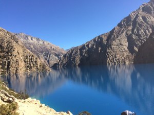
Phoksundo Lake
4 to 7 a day · 2 rest days11days
3,900 mAbove Ringmo (about 3,900 m)
Moderate
The walk
Region · east of Far West, west of Mustang
Dolpo, in the far north-west, is one of the most remote parts of Nepal: Tibetan Buddhist villages, high passes and the turquoise Phoksundo Lake in Shey Phoksundo National Park. Upper Dolpo is a restricted area, reached on long, wild walks.
Tap Dolpo on the map to see what is here; tap another region to go there.
The walks here

Two ways to walk here
| The shortestPhoksundo Lake | The highestUpper Dolpo | |
|---|---|---|
| Days | 11 days | 23 days |
| Highest point | 3,900 m | 5,360 m |
| Grade | Moderate | Strenuous |
| On the trail | Quiet | Quiet |
| Way in | With a flight | With a flight |
When to walk here
Dolpo lies partly in the rain shadow, so the summer months are good for the high valleys. The flights to Juphal depend on the weather, and winter closes the passes.
Good to know
Stories from here
Other trails here can be walked too. Tell me which one, and we plan it together.
Write to me